The city was located then along Manila Bay and south of the Pasig River entrance, before 20th-century reclamations obscured the city from the bay. Guarding the city is Fort Santiago, a citadel located at the mouth of the river. Construction of its thick defensive walls were started by the Spaniards in the late 16th century to protect the seat of the Spanish government from foreign invasions (most notably British and Dutch) and raiding Chinese sea pirates.
In an October 2010 report titled Saving Our Vanishing Heritage, the Global Heritage Fund identified Intramuros along with Fort Santiago, as one of 12 worldwide sites "On the Verge" of irreparable loss and destruction, citing insufficient management and development pressures.[5]
History
Pre-Hispanic period
The strategic location of Manila, being on the mouth of Pasig River and along Manila Bay, made it an ideal location for Tagalog and Kapampangan tribes and kingdoms to trade with other Asian civilizations, including Chinese, Indian and Islamic merchants who had come from China, India, Borneo and Indonesia.Before the first arrival of Europeans in Luzon, it became part of Indianized empire of Majapahit around the 14th century, according to the epic eulogy poem Nagarakretagama which inscribed its conquest by Maharaja Hayam Wuruk.[6][6] The region was invaded around 1485 by Sultan Bolkiah and became part of the Sultanate of Brunei.[7] The site of Intramuros was part of the Islamic kingdom of Maynila ruled by Datus, Rajahs and the Sultan.
[edit] Spanish colonial period
[edit] Conquest of Manila
In 1564, Spanish explorers led by Miguel López de Legazpi sailed from Mexico, and arrived on the island of Cebu on February 13, 1565, establishing the first Spanish colony in the Islands. Having heard of the rich resources of Manila from the natives, López de Legazpi dispatched two of his lieutenant-commanders, Martín de Goiti and Juan de Salcedo to explore the northern regions of the Visayas.In 1570, the Spaniards arrived in the island of Luzon. After quarrels and misunderstandings had erupted between the Islamic natives and the Spaniards, both groups fought for the control of lands and settlements. In 1571, after several months of warfare, the natives were defeated, and the Spaniards made a peace pact with the Muslim tribal councils of Rajah Sulaiman III, Rajah Lakandula, and Rajah Matanda; who, in return, handed over Manila to the Spaniards.
Construction of the wall
The planning of the city of Manila was commenced by Santiago de Vera, the sixth governor-general on the islands.[9] The plans for Intramuros were approved by King Philip II of Spain's Royal Ordinance issued in San Lorenzo, Spain.Gomez Perez Dasmarinas, the next governor, brought with him from Spain the royal instructions to carry into effect the above decree. Hence the work began in 1590 and continued under many governors till 1872. As this construction was carried on during different periods, often far apart, the building was not executed, therefore, according to any uniform plan.[9]
Gov. Juan de Silva executed certain work on the fortifications in 1609 which was improved by Juan Niño de Tabora in 1626, and again improved by Diego Fajardo Chacón in 1644, the erection of the San Diego Bastion (Baluarte de San Diego) being completed in that year. This bastion shaped like an "ace of spades" is the southernmost point of the wall and appears to have been the first of the large bastions added to the encircling walls, then of no great height nor of finished construction.[10] It was the former site of Nuestra Señora de Guia, the very first stone fort of Manila.[11]

Inside Intramuros
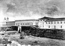
The main square of the city was Plaza Mayor (later known as Plaza McKinley and Plaza de Roma) in front of the Manila Cathedral. East of the plaza was the Ayuntamiento (City Hall) and facing it was the Governor's Palace, the official residence of the Spanish viceroyalties to the Philippines. The earthquake of June 3, 1863 destroyed the three buildings and much of the city. The residence of the Governor-General was moved to Malacañang Palace located about 3 km (1.9 mi) up on Pasig River. The two previous buildings were later rebuilt but not the Governor's Palace.Inside the walls are other Roman Catholic churches, the oldest being San Agustin Church (Augustinians) built in 1607. The other churches built by the different religious orders - San Nicolas de Tolentino Church (Recollects), San Francisco Church (Franciscans), Third Venerable Order Church (Third Order of St. Francis), Santo Domingo Church (Dominican), Lourdes Church (Capuchins), and the San Ignacio Church (Jesuits) - has made the small walled city the City of Churches.
Intramuros became the center of large educational institutions in the country.[3] Convents and church-run schools such as the Universidad de Santo Tomás, the Colegio de San Juan de Letrán and the Ateneo Municipal de Manila were run by the Dominicans and the Jesuit religious orders.
Residents within the wall
As opposed to what was the norm in other European colonies at the time, Spanish authorities allowed all racial groups to settle inside Intramuros. Sir John Bowring, Governor General of British Hong Kong, a well-seasoned traveler who had written several books about the different cultures in Asia, was favorably impressed by the lack of racial discrimination and described the situation as "admirable" on a visit to Intramuros, part of his trip to the Philippines during the 1870s.
| “ | The lines separating entire classes and races, appeared to me less marked than in the Oriental colonies. I have seen on the same table, Spaniards, Mestizos (Chinos cristianos) and Indios, priests and military. There is no doubt that having one religion forms great bonding. And more so to the eyes of one that has been observing the repulsion and differences due to race in many parts of Asia. And from one (like myself) who knows that race is the great divider of society, the admirable contrast and exception to racial discrimination so markedly presented by the people of the Philippines is indeed admirable.[12] | ” |
Physical features of the walls
The outline of the defensive walls of Intramuros is irregular in shape, following the contours of Manila Bay and the curvature of the Pasig River. The walls covered an area of 64 hectares (160 acres) of land, surrounded by 8 feet (2.4 m) thick stones and high walls that rise to 22 feet (6.7 m). An inner moat (foso) surrounds the perimeter of the wall and an outer moat (contrafoso) surrounds the walls that face the city.Defense structures
Several bulwarks (baluarte), ravelins (ravellin) and redoubts (reductos) are also strategically located along its massive walls following the design of medieval fortifications. The seven bastions (clockwise, from Fort Santiago) are the Bastions of Tenerias, Aduana, San Gabriel, San Lorenzo, San Andres, San Diego, and Plano.[13]
Main article: Gates of Intramuros
Before the American Era, entrance to the city was through eight gates or Puertas namely (clockwise, from Fort Santiago) Puerta Almacenes, Puerta de la Aduana, Puerta de Santo Domingo, Puerta Isabel II, Puerta del Parian, Puerta Real, Puerta Sta. Lucia, and Puerta del Postigo.[15] Formerly, drawbridges
were raised and the city was closed and under sentinels from 11:00 pm
till 4:00 am. It continued so until 1852, when, in consequence of the
earthquake of that year, it was decreed that the gates should
thenceforth remain open night and day.[13]American Colonial Period
On August 13, 1898, the American flag was raised in Fort Santiago indicating the start of American rule over the city.[16] The Ayuntamiento became the seat of the Philippine Commission of the United States in 1901. Fort Santiago became the headquarters from the Philippine Division of the United States Army.In the early years of American occupation, drastic changes were made in the walls and character of the city. In 1903, the walls from the Santo Domingo Gate all the way to the Almacenes Gate were removed as the wharf on the southern bank of the Pasig River was widened and improved. The stones removed were used in various constructions around the city.
The walls were also breached in four areas to ease up access to the city: the southwestern end of Calle Aduana (Aduana Street, now Andres Soriano Jr. Ave.); the eastern end of Calle Anda (Anda Street); the northeastern end of Calle Victoria (Victoria Street, previously known as Calle de la Escuela, Street of the School); and the southeastern end of Calle Palacio (Palacio Street, now General Luna Street).
The double moats that surrounded Intramuros were deemed unsanitary and were filled in with mud dredged from Manila Bay where the present Port of Manila is now located. The moats were transformed into a municipal golf course by the city. The walls of the city which were located along Manila Bay are now obstructed from view from Manila Bay by the reclamations for the expansion of Luneta Park, and by the construction Manila Hotel and the Port of Manila.[17]

World War II
On 8 December 1941, the Japanese Imperial Forces had bombarded the Philippines and the following days of intense assault led to the destruction of the Santo Domingo Church and the University of Santo Tomas. The very first casualties of the war. As the situation deteriorated, General McArthur declared Manila as an "Open City" to spare Manila and its historical sites from destruction as provided by the The Hague Convention. The old walled city remained intact until 1945.American troops reentered Manila in January 1945, and intense close combat occurred between the American GIs, local Filipino troops of the Philippine Commonwealth Army units, recognized guerrillas and the 30,000 Japanese defenders. As the battle dragged on, the Japanese destroyed the city, razing buildings and slaughtering Filipino civilians (see Manila Massacre). The Imperial Japanese Army was slowly pushed back, eventually retreating into the Intramuros district. General MacArthur, though opposed to the bombing of the walled city, approved heavy shelling which resulted in deaths of 100,000 Filipino civilians.
At the end of World War II, all of the structures in Intramuros were destroyed by both the Japanese Imperial Forces and U.S. Air Force. Of twenty eight churches and chapels inside the old wall city, only one structure, the Church of San Agustin survived the heavy bombardment but not without any damage.[18][19][20]
Rehabilitation of the Walled City

In 1979, the Intramuros Administration was created by virtue of Presidential Decree no. 1616, signed by then President Ferdinand Marcos on April 10 of that year. Since then, the Intramuros Administration (IA) has been slowly restoring the walls, the sub-features of the fortification, and the city within. The remaining five original gates have been restored or rebuilt: Isabel II Gate, Parian Gate, Real Gate, Sta. Lucia Gate and the Postigo Gate. The four entrances made by the Americans by breaching the walls at four locations are now spanned by walkways thereby creating a connection, seamless in design and character to the original walls.
In 2003, during the Visit Philippines Year, Tourism Secretary Richard J. Gordon cleaned up Intramuros with the help of student and civilian volunteers as well as raised funds to improve the lighting of the place and build a lights-and-sound museum.
Present day Intramuros

Of the eight churches that were located within its walls, only two remained: San Agustin Church, the oldest building in Manila completed in 1607, and the Manila Cathedral, which was reconstructed in the 1950s. The other religious orders reconstructed their churches away from Intramuros after the war. There are plans of reconstructing the San Ignacio Church in its vacant original location to serve as an ecclesiastical museum for the IA collection.[22]
Fort Santiago is now a well-maintained park where visitors can enjoy the nostalgic legacy of the bygone Spanish Colonial Era within its gardens. Next to Fort Santiago is one of the big projects of Intramuros Administration - the reconstruction of the Maestranza Wall - the wall removed by the Americans in 1903 to widen the wharves thus opening the city to Pasig River. One of the future plans of the administration was to complete the perimeter walls that surround the city making it completely circumnavigable from the walkway on top of the walls.[23]
No comments:
Post a Comment